Category Archives: Sea level rise

Amid flooding and rising sea levels, residents of one barrier island wonder if it’s time to retreat

The Washington Post, by  Frances Stead Sellers,  Nov. 9, 2019 PST

OCRACOKE, N.C. — On any normal late-fall day, the ferries that ply the 30 miles between Swan Quarter and this barrier island might carry vacationing retirees, sports fishermen and residents enjoying mainland getaways after the busy summer tourist season.

But two months ago, Hurricane Dorian washed away all signs of normalcy here. After buzz-cutting the Bahamas, the giant storm rolled overhead, raising a seven-foot wall of water in its wake that sloshed back through the harbor, invading century-old homes that have never before taken in water and sending islanders such as post office head Celeste Brooks and her two grandchildren scrambling into their attics.

Ocracoke has been closed to visitors ever since. Island-bound ferries carry yawning container trucks to haul back the sodden detritus of destroyed homes. And O’cockers — proud descendants of the pilots and pirates who navigated these treacherous shores — are faced with a reckoning: whether this sliver of sand, crouched three feet above sea level between the Atlantic Ocean and Pamlico Sound, can survive the threats of extreme weather and rising sea levels. And if it can’t, why rebuild?

“That’s the unspoken question. That’s what nobody wants to say,” said Erin Baker, the only doctor to serve this community of 1,000. “It’s a question of how do we continue to have life here.”

Scientists have long warned that Ocracoke’s days are numbered, that this treasured island is a bellwether for vast stretches of the U.S. coast.

“Virtually everyone from Virginia Beach south to the U.S./Mexico border is going to be in the same situation in the next 50 years,” said Michael Orbach, professor emeritus of marine affairs at Duke University. “And it’s only going to get worse after that.”

If Ocracoke’s ultimate prognosis is grim, Tom Pahl, the township’s county commissioner, remains committed to its recovery.

“Is this really sustainable? The answer is pretty clearly no,” he said. “But what’s the timeline? No one has been able to say, ‘You’ve got 15 years, 40 years, 100 years.’ The clear-eyed vision is resiliency then retreat.”

[As North Carolina focuses on getting ahead of hurricanes, some residents are hesitant to move]

The disaster has in some ways shortened people’s outlook.

“I don’t think we’re thinking that far ahead right now,” said Monroe Gaskill, 64, echoing in the distinctive island brogue the immediate concerns of many “ol’ toimers”: whether the island will be open in time for duck-hunting season later this month; where students will study next semester when they have to relinquish their temporary classrooms in the old Coast Guard Station; and what will become of all the displaced residents, who are holed up in rental units, once the tourists return next Easter.

Even as some houses are being bulldozed, neighbors are working together to raise others.

“Now I know there is no such thing as high enough,” said Janet Spencer behind the counter of the hardware store, which reopened without power right after the storm. She and her husband jacked up their home 18 years ago — just one cinder block too few to keep out Dorian. Still, she said, long-term residents won’t leave.

“It’s the only thing we know,” she said.

The home of Edward and Stella O’Neal is torn down due to damage caused by flooding during Hurricane Dorian in Ocracoke. (Daniel Pullen/for The Washington Post)
Monroe Gaskill, a commercial fisherman and licensed hunter guide, said he thinks people on the island are more focused on their immediate concerns right now. (Daniel Pullen/for The Washington Post)

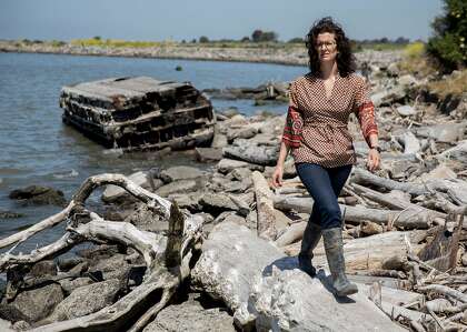
There are hazards everywhere, said Amy Howard, 47, a local historian and craft store manager, and hurricanes have shaped the culture of this storied village. She showed off the floorboards her great-grandfather cut out in 1933 to relieve pressure from mounting water and prevent the house from floating off its foundations. The building was raised in 1944 after a storm, and her father plans to elevate it further.

Alton Ballance, a descendant, like Gaskill and Howard, of the island’s earliest white settlers, has heard the call to retreat. “Time to get off that island!” one friend, an ocean scientist, has told him. “There may come a day when it’s not feasible to continue,” Ballance concedes, but for now he is methodically stripping out the old family home and installing new electrical outlets waist-high.

“It’s easy for people in government and sometimes in the media to target a small place like this,” Ballance said, rocking back and forth on a porch swing outside the room where his mother was born.

The Federal Emergency Management Agency provided support for rebuilding roads and other infrastructure. But a recent decision to deny residents individual assistance, which would have helped with temporary housing, has provoked ire when so many coastal communities received funds after hurricanes such as Sandy in 2012.

FEMA said it provides the funding only when state and local resources are overwhelmed.

North Carolina Gov. Roy Cooper has signaled his commitment to rebuilding. But the islanders’ sense of injustice reflects a broad dilemma, according to Rob Young, director of the Program for the Study of Developed Shorelines at Western Carolina University — a lack of clarity about which parts of the nation’s threatened shoreline can and should be protected.

“There is no clear national plan,” said Young, so FEMA’s decision “comes across as arbitrary.”

While Young does not advocate mass migration, wetter storms are raising questions about using taxpayer money to rebuild coastal communities.

“At some point, there is going to be a breaking point,” he said, “when the public sector is either not going to want or to be able to afford to accept the risk.”

Meanwhile, the future of the Outer Banks is made more precarious by development, said Stanley Riggs, who devoted his career at East Carolina University to studying the state’s 10,000-mile coastline.

“We’re loving these islands to death,” Riggs said, constructing roads and bridges to bring in tourists and blocking the natural flow of tides and storms that over millennia have shaped the 175-mile string of shifting sand banks.

What remains of Highway 12 is piled up to be hauled away after flooding caused by Hurricane Dorian. (Daniel Pullen/for The Washington Post)

Riggs served on a state advisory panel that in 2010 predicted more than three feet of sea-level rise by 2100, prompting a backlash from lawmakers skeptical of climate change and developers.  A compromise bill, based on a shorter timeline, passed in 2012, even as the jeopardy has become clearer here: The coastline of Cape Hatteras, north of Ocracoke, is eroding rapidly, retreating by more than a mile since Hurricane Isabel in 2003; to the south, once-vibrant Portsmouth is a ghost town.

Sitting outside the makeshift classrooms, middle school science teacher Patricia Piland described how climate science has become real for her eighth-graders. Their curriculum this semester focuses on the hydrosphere, but she has moderated her message for students shell shocked by their narrow escape.

“One girl said, ‘So, we’re screwed.’ ” Piland recalled. “I told them I believe we can plan for sea-level rise.” Doing so, she said, will require working with nature rather than responding to the demands of developers.

Enrollment at the school has dropped from 174 to 157 since the storm, and Brooks, the post office head, is seeing the community fray slightly as families file change-of-address forms. “There will be more,” she predicted, weeping as she recalled the trauma of being trapped by rising water.

Some people who lost their jobs took off quickly. Others are still deciding. Tom Parker, 66, who moved here 20 years ago, wiped away tears as he sat under the live oak tree where he has made a steady income charging tourists $1 to have their photo taken among its gnarled branches.

“I’m tired of having this constant risk of having it all destroyed,” he said.

But for many people who come here to wait tables or clean motel rooms, Ocracoke remains a place of opportunity, not retreat. The storm was a setback for Idalid Maldonado, a seasonal worker already facing problems this year with her visa, but she hopes it’s only a temporary one.

She set down the wheelbarrow she has been using to lug the salt-stained contents out of guest rooms to ponder whether she will be back next summer.

“I don’t know,” Maldonado said. “I don’t know.”

About one-third of Ocracoke’s population is Latino, many of whom came like Maldonado to serve summer visitors and then were seduced by the gentle year-round rhythm of island life where children can roam free.

“We talked about moving, but here, it’s a special place,” said Gloria Benitez-Perez, whose husband is in the construction business and built their house on stilts. “We are going to be fine.”

A pile of debris grows in Ocracoke. (Daniel Pullen/for The Washington Post)
Local artists painted and displayed signs to boost morale in Ocracoke after Hurricane Dorian. (Daniel Pullen/for The Washington Post)

But, like the shipwrecks that surface after storms, existing problems gained prominence following Dorian’s blow. Stanley “Chip” Stevens, owner of Blackbeard’s Lodge, named after the fearsome buccaneer who was beheaded here, said there has been no full accounting of Dorian’s damage and of the impact on people living in sheds and trailers who are “the backbone of our service workforce.”

He advocates more building, not less, to support the “shadow economy” on which Ocracoke — and impoverished Hyde County — depend.

“What the island needs is affordable housing,” Stevens said.

Aid workers, meanwhile, comment on the extraordinary challenges of offshore construction. Every box of nails, each bottle of bleach and all the two-by-fours have to be driven out through low-lying country before being loaded for the almost three-hour ride across the Sound. Contractors face a round-trip commute of six hours or more, or they have to find a place to stay.

There is another, shorter, route out of Ocracoke.

North of the village, past the discarded cars and the corroded appliances, Highway 12 leads through the National Park’s windswept dunes to an isolated ferry terminal.

Dorian chewed up the tarmac. Only four-wheel drives are allowed to make the trip, tucking in behind a tow truck that leads over rutted, chassis-scraping sand to the waiting Hatteras ferry.

Once the road is passable — perhaps by late November — it will provide a lifeline. But it won’t restore normalcy or eliminate the sense that this little paradise is in limbo.

“The hard part hasn’t started yet,” said Baker, the island doctor, who is monitoring patients’ stress at the metal mobile clinic shipped in to replace her flooded facility. The hurricane that pummeled the Bahamas had reduced to a Category 1 by the time it swamped Ocracoke, she said.

“There’s a whole new level of fear for those who stay.”

Erin Baker, the only doctor in the community of 1,000, in front of her temporary clinic. Her facility was damaged by flooding from Hurricane Dorian. (Daniel Pullen/for The Washington Post)

Something strange is happening to Greenland’s ice sheet

What should be like a snowcone is becoming more like a popsicle, speeding up the runoff from the melting ice sheet.

When the remnants of Europe’s second summertime heat wave migrated over Greenland in late July, more than half of the ice sheet’s surface started melting for the first time since 2012. A study published Wednesday in Nature shows that mega-melts like that one, which are being amplified by climate change, aren’t just causing Greenland to shed billions of tons of ice. They’re causing the remaining ice to become denser.

“Ice slabs”—solid planks of ice that can span hundreds of square miles and grow to be 50 feet thick—are spreading across the porous, air pocket-filled surface of the Greenland ice sheet as it melts and refreezes more often. From 2001 to 2014, the slabs expanded in area by about 25,000 square miles, forming an impermeable barrier the size of West Virginia that prevents meltwater from trickling down through the ice. Instead, the meltwater becomes runoff that flows overland, eventually making its way out to sea.

As the ice slabs continue to spread, the study’s authors predict more and more of Greenland’s surface will become a “runoff zone,” boosting the ice sheet’s contribution to global sea level rise and, perhaps, causing unexpected changes.

It’s easy to think of Greenland as a solid, impenetrable hunk of ice. But in reality about 80 percent of the ice sheet’s surface is like a snowcone: A dusting of fresh snowfall covers a thick layer of old snow, called firn, that’s slowly being compressed into glacier ice but still contains plenty of air pockets. When the top of this snow cone melts in the summer, liquid water percolates down into the firn, which soaks it up like a 100-foot-thick sponge.

MacFerrin and his colleagues got their first hint that the firn may be losing its absorbency in the spring of 2012, when they were drilling boreholes through the firn in southwest Greenland. They started finding dense, compacted layers of ice in core after core, just below the seasonal snow layer. It was, MacFerrin says, as if a “turtle shell” had formed over the firn.

MacFerrin and his colleagues immediately wondered whether that shell might be preventing meltwater from percolating into the firn.

“That was May of 2012,” MacFerrin says. “And July was this record-breaking melt year, and we got our answer very quickly.”

That summer, for the first time on record, meltwater from this part of Greenland visibly started to flow away as runoff.

Realizing they had witnessed something significant, the researchers set about drilling more cores over a larger region to see how extensive the ice shell was. They discovered that it spanned a transect 25 miles long and was having widespread effects on local hydrology.

Those findings, published in 2016 in Nature Climate Change, were the springboard for the new study. Using radar data from NASA’s IceBridge airborne campaign, as well as ground-based surveys, MacFerrin and his colleagues have now created a first-of-its-kind map of ice slabs across the entire surface of Greenland.

Based on modelling results, the researchers think the shell began to form and spread widely in the early 2000s. As of 2014, it covered some 4 percent of Greenland’s surface, according to the new analysis. Every summer that extensive melting occurs, it gets thicker and spreads inland to colder, higher ground.

“Every handful of years, these big melt summers are doing a number on the firn,” MacFerrin says. “That’s causing this whole process to grow inland pretty quickly.”

This photo is a segment of a firn core, essentially a baby ice slab that eventually will grow into a meters-thick slab of ice.

PHOTOGRAPH BY DR. KAREN ALLEY

Sea level rise and unexpected consequences 

Ice slabs have already caused Greenland’s runoff zone to expand by about 26 percent, according to the new study. So far the additional runoff has only added about a millimeter to global sea levels. Greenland now contributes a little under a millimeter per year to rising sea levels, through a combination of icebergs breaking off glaciers and melt occurring at the surface and base of the ice sheet.

But if Greenland’s surface hardens more, runoff could rise dramatically. Under a worst-case scenario where carbon emissions continue to climb until the end of the century, the researchers calculated that ice slab proliferation could add up to 3 inches of sea level rise by 2100, boosting the ice sheet’s overall sea level rise contribution by nearly a third. In both a middle-of-the-road scenario where emissions peak by mid-century and the high emissions one, the amount of runoff from Greenland’s interior roughly doubles by century’s end.

But more runoff is only one potential consequence of the transformation taking place in Greenland’s ice. Kristin Poinar, a glaciologist at the University of Buffalo who wasn’t involved in the study, pointed out that slabs of solid ice aren’t nearly as reflective as bright white snowfall.

“And so, if we start getting these ice slabs forming near the ice sheet’s surface, it could potentially…cause the ice sheet to absorb more solar radiation and warm up,” she says. “And that would create more ice slabs.”

And runoff from ice slabs doesn’t have to flow into the ocean, said Indrani Das, a glaciologist at Columbia University who wasn’t involved in the study. She worries about how it could seep into the large crevasses that exist at lower elevations on the ice sheet. From there, the runoff could, potentially, flow all the way down to bedrock, lubricating the zone where the ice makes contact with it.

“That could make the ice sheet flow faster,” Das says, which could cause glaciers to spill their contents into the ocean more quickly, like ice cream sliding off a piece of cake.

To Poinar, the most significant contribution of the new study is that it will allow scientists to improve their projections of future sea level rise, giving coastal communities the information they need to prepare. At the same time, the study highlights the fact that the more carbon we spew into the atmosphere, the more we’re likely to transform Earth’s northern ice sheet in insidious and unexpected ways. And that could have consequences that are difficult to anticipate.

“We have never observed an ice sheet behaving this way before,” Poinar says. “It’s unprecedented in human scientific history.”

Report: How SF Bay communities should combat sea-level rise

[Editor: Download the Adaptation Atlas  here.  There is also a 2-pg. “Highlight Bullets” and an Adaptation Atlas Interactive website. For more details about this project, visit sfei.org/adaptationatlas. To participate in a report launch webinar being held on May 2 at 2:00 PM PDT, please visit http://bit.ly/adaptationatlaswebinar.  – R.S.]

Blueprint to battle Bay Area sea-level rise focuses on natural solutions

By Peter Fimrite, May 2, 2019 
The Oro Loma marshland along the Heron Bay Trail in Hayward is part of San Francisco bay’s 400 miles of shoreline. Photo: Jessica Christian / The Chronicle

A blueprint outlining how San Francisco Bay communities should combat sea-level rise was released early Thursday by ecosystem scientists and urban planners who envision a ring of man-made reefs, rocky beaches and graded marshlands around the largest estuary on the Pacific coast.

The carefully designed features, outlined in the 255-page San Francisco Bay Shoreline Adaptation Atlas, would in many cases replace or bury seawalls, rip rap, culverts and other crude fortifications that experts say won’t hold up as the climate warms and water rises.

The idea, developed over the past two years by the San Francisco Estuary Institute and SPUR, a San Francisco urban planning research center, is to build eco-friendly features that support wildlife and absorb, rather than repel, the rising tides.

The report comes at a critical time: The U.S. Geological Survey recently calculated that property damage from sea level rise in the Bay Area could exceed $100 billion by the end of the century if nothing is done to stop carbon dioxide emissions. The Union of Concerned Scientists said 4,100 homes in San Mateo County and nearly 4,400 in Marin County could be underwater by 2045.

A duck and ducklings swim along a waterway inside the Oro Loma marshland along the Heron Bay Trail in Hayward, Calif., Wednesday, May 1, 2019. Photo: Jessica Christian / The Chronicle

The causes of climate change need to be addressed, but at the same time, scientists and planners need to brace for the fallout, experts say. Climate scientists say the sea level at the mouth of San Francisco Bay has risen almost 8 inches over the past century.

“The Bay Area is ground zero for sea-level rise,” said Warner Chabot, executive director of the Estuary Institute, who predicted the atlas would become a national model. “We have a trifecta threat of sea level rise, groundwater rising and lowland flooding from extreme weather patterns, and that guarantees a soupy shoreline future for the Bay Area.”

The plan, funded by the San Francisco Bay Regional Water Quality Control Board, is the first attempt in the Bay Area to develop a collaborative regional plan to both enhance the ecosystem and protect cities around the bay from the potential ravages of climate change.

The report was put together over the past two years in collaboration with scientists, planners and policymakers across the region. It provides graphics, explanations of ecological science and a framework for all nine Bay Area counties to build nature-like shorelines that would protect their communities.

San Francisco Bay has 400 miles of shoreline, including airports, landfills, marinas, wetlands, beaches, ports and residential neighborhoods.

The researchers divided the shoreline into 30 separate “operational landscape units” based on shoreline geology, terrain and infrastructure. They developed strategies for each section, including projects to re-route creeks into wetland areas, place shell structures offshore, use sediment to bolster shoreline elevations and create beaches to replace rip rap, the concrete or stone rubble placed along banks to prevent erosion.

The study incorporates in its recommendations restoration projects that are under way, like one at Giant Marsh in North Richmond. The California State Coastal Conservancy is installing 350 reef structures there, planting eel grass and connecting the wetlands to upland habitat. The goal is to create a sloping tidal system that starts in the water with oyster shell mounds that reduce wave action, then shifts into eel grass in the sub-tidal area and eventually marshland that slows down storm surges.

Marilyn Latta of the State Coastal Conservancy holds a miniature version of a reef structure, a living shoreline element that acts as a home for oysters and to combat sea level rise, placed off the Point Pinole shoreline in Richmond. Photo: Jessica Christian / The Chronicle
Oyster blocks placed by the State Coastal Conservancy as a living shoreline element designed to act as a home for native oysters and combat sea level rise are seen in the water off the Point Pinole shoreline in Richmond, Calif. Wednesday, May 1, 2019. Photo: Jessica Christian / The Chronicle

Wetlands restoration has been going on for years in the former salt ponds in the South Bay and along Highway 37 in the North Bay, buffer zones that the atlas recommends expanding. The report recommends building a Highway 37 bridge or causeway so that tidewater can better migrate into the restored wetlands.

At least 18,000 acres of potential wetlands in the Bay Area have been acquired and are slated for restoration. The goal is to eventually restore 100,000 acres of bay marsh, much of it in the Napa and Suisun areas, along the Petaluma River and in the South Bay.

Another idea in the report is to reroute Santa Clara County’s Calabazas Creek, which was diverted long ago, so that it flows into restored wetlands that need the sediment from the creek to grow. The wetlands near Calabazas are among 16,000 acres of former salt ponds in the South Bay that were cut off from the bay by earthen berms and dikes.

Alameda Creek, Novato Creek and many other waterways in the Bay Area should also be realigned to help build up the marshes, said Julie Beagle, deputy director of the institute’s resilient landscape program and lead author of the study.

“We can use the sediment that comes out of our hills,” Beagle said. “We have to think of our sediment as a resource.”

Scientist Amy Richey, with the San Francisco Estuary Institute, views a defensive shoreline on the Heron Bay Trail in Hayward. Photo: Jessica Christian / The Chronicle

The authors collaborated with the California Department of Transportation, the Sonoma Land Trust and several cities in Marin and Sonoma counties to identify places along Highway 37 and near Petaluma, Napa and Sonoma creeks where new wetlands could be created.

The East Bay also is a critical area, according to the report’s authors. One example of a successful strategy, they said, is the horizontal levee built near a wastewater facility by the Oro Loma Sanitary District in Hayward. The levee uses vegetation planted on a slope that covers a vertical wall previously used to break waves. This setup allows the district to protect the facility and filter-treated wastewater through the ground instead of dumping it in the bay.

Beagle said she would like to see the beaches that once existed from Point Richmond to the Bay Bridge restored. Instead, the Highway 80 corridor is now protected mostly by rip rap, which she said speeds up erosion by essentially increasing the power of the waves that smack into the rock.

“There’s no reason in my mind that it can’t be a beach,” she said. “There is a huge amount of mudflats and shallow water, pocket beaches and small marshes. This is a place where different types of beaches would fit. You could even cover the rip rap with sand or a coarser, more porous material that would soften the wave action.”

Other strategies would have to be used for areas with less room for restoration, like Foster City, which is protected by seawalls. One solution would be to engineer shell beaches or jetties that would knock down the waves and create green infrastructure to work in coordination with the wall.

And, Beagle said, there is no way around the decrepit seawall in San Francisco, which is all that keeps the bay from reclaiming inland blocks built on landfill, including portions of the Financial District. Still, she said, it can be rebuilt as a green seawall, with pockets and textures that promote the growth of submerged aquatic vegetation, invertebrates, small mammals and fish.

The report does not address how much money would be needed — or where it would come from — to complete the projects outlined in the report. Up to $100 billion will be needed over the next 20 years just to rebuild the Bay Area’s aging shoreline infrastructure, according to recent estimates.

“We only have a few years to get a lot of these projects going because natural solutions take time to evolve,” Beagle said. “We need to get moving.”

Peter Fimrite is a San Francisco Chronicle staff writer.

SF Chron Perspective: Facing the coming flood with a sense of optimism

Repost from the San Francisco Chronicle

Facing the coming flood with sense of optimism

By Caille Millner, Oct. 19, 2018 2:12 p.m.
The 2017 Russian River flood in Guerneville. A new U.N. climate report says we have about 12 years to do something huge on climate change. Photo: Santiago Mejia / The Chronicle 2017

After I read the United Nations’ new apocalyptic climate change report, I looked to see when my house was going to be underwater.

For this grim task, I set out to model different possibilities with an online sea level rise tool from Cal-Adapt, a public database for research from California scientists and researchers. (Isn’t the internet amazing? It provides those of us who believe in climate change with all the tools we need to find out when it’s going to swallow us whole, and those of us who aren’t willing to be convinced with all the conspiracy theories we need for political arguments.)

I zoomed in to my street and tried the tool’s first option, “no rise.”

My neighborhood remained gray and dry, untouched by the neon blues of inundation.

Comforted, I tried half a meter. That’s about 1.6 feet, which sounded like a lot until I remembered that the California Coastal Commission has told cities to be prepared for more than 10 feet of ocean rise by 2100.

My house wasn’t underwater yet, but suddenly I could no longer get downtown. Nearly 10 feet of water had inundated the area just north of Mission Bay. San Francisco had lost an Interstate 280 exit, and it’s pretty much assured that all of my Muni buses were getting re-routed as well.

I switched to 1 meter (about 3.3 feet).

My house was still OK, but the water was approaching fast.

Many buildings in the surrounding neighborhoods, including Mission Bay and the Dogpatch, were underwater at least some of the time. The Bayview and Hunters Point neighborhoods were receding into marshland. San Francisco’s Board of Supervisors just approved the construction of a new community in India Basin this week that’s going to be soggy as soon as it’s built.

At 1.41 meters (4.6 feet), Hunters Point was half as large as it should have been, South Beach was surrounded by water on all sides, and Interstate 280 was swamped heading out of Potrero Hill.

Ten feet of ocean rise by 2100. I imagined myself standing on my roof and waving a white T-shirt for rescue. In fact, I should start practicing right now — according to that new U.N. climate report, the party starts in just 12 years. Given the level of anxiety I feel about all of this, it’s going to take me at least six years just to loosen up my spine.

Bad joke, I know. And the truth of the matter is that cynical humor — which is quite frankly the most natural human reaction to the news that the world is about to be flooded and there’s nothing you personally can do to stop it — is not going to get us out of this mess.

So what kind of attitude will get us out of this?

I’ve been thinking about that a lot, partially because I’m so terrified by all of the political inaction and partially because I’ve noticed so many otherwise indomitable people responding to the news on climate change with a sense of helplessness.

Like cynical humor, helplessness is a natural reaction. But it won’t work, and neither will telling other people to give up the benefits of modernity to save the Earth. (Everyone I meet in Berkeley is eager to tell me how climate change will evaporate if we all just stop flying on planes, eating meat and having children, but I have yet to see any of them take their own advice.)

What might work?

Optimism.

It’s hard to find optimism anywhere in America in October 2018, but I’m finding it in the lawsuit brought by 21 young people against the U.S. government for failing to tackle climate change.

Levi Draheim, 10 (center), and other youth activists suing the Trump administration over climate change in San Francisco on Dec. 11. Photo: Gabrielle Lurie / The Chronicle 2017

It’s scheduled to go to trial on Oct. 29, and while the Justice Department has asked the Supreme Court to block it from happening, something about their action feels … antediluvian. A lot of that has to do with the fact that the children are unshaken by the size of the fight they’ve taken on.

“I believe that the momentum is on our side,” said one of the plaintiffs, then-17-year-old Nathan Baring, when the kids were presenting their lawsuit before the Ninth Circuit Court of Appeals in San Francisco in December.

The youngest plaintiff, 11-year-old Levi Draheim of Florida, has said that if he doesn’t do this, he may not have a home when he’s older.

It’s the simplest reason to take on this fight, and it’s also the most inspiring one. It smacks of can-do spirit, a trait that used to be associated with American values. I think it’s time we brought it back again.

Why not make fighting climate change our next national challenge, like putting a man on the moon once was? Why not at least believe we can do that, and behave accordingly?

I can tell you this much: Optimistic action sounds like a lot more fun than clicking for your personal flood zone.

Caille Millner is an editorial writer and Datebook columnist for the San Francisco Chronicle. She has worked at the paper since 2006. On the editorial board, she covers a wide range of topics including business, finance, technology, education and local politics. For Datebook, she writes a weekly column on culture.She is the recipient of the Scripps-Howard Foundation’s Walker Stone Award in Editorial Writing and the Society of Professional Journalists’ Editorial Writing Award.