Candidate Amy Hirsh pulls even further ahead with what may be an insurmountable lead
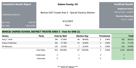
The Solano County Registrar of Voters (ROV) posted a second round of vote totals last night at 8:40 PM. The results show candidate Amy Hirsh is still leading by a significant margin.
The ROV reported about 50 unprocessed provisional and mail-in ballots remaining, and it will continue to count mail-in ballots as they trickle in through the next week or so.
Low turnout
While the number of late mail-in ballots could swell dramatically during this next week, it is much more likely that voter turnout for this Special Election will remain where it is: very low.
As of today, the voter turnout for this Special Election sits at about 25%. As a basis for comparison, the 2022 General Election saw Benicia’s voter turnout at a robust 65% — meaning about 65% of eligible voters chose to cast ballots.
Even though it is unlikely either Ariana Martinez or Ali Mansouri will be able to catch up to Ms. Hirsh’s lead, final results will be posted here when they become available.
Here is the current count:
Updated results from the Solano County ROV show Amy Hirsh leading with what is likely an insurmountable advantage.
Candidate Amy Hirsh leads with about 23% of the vote counted
The Solano County Registrar of Voters posted its first round of vote totals at 8:01 PM tonight, showing candidate Amy Hirsh leading by a significant margin. Only 943 out of 4,110 potential ballots have been counted so far, and these have all been mail-in ballots. Ballots cast in person have apparently not yet been counted.
Stay tuned! We will continue to keep an eye on the results and report on them as we can.
Here is the current count:
Early results from the April 11 election show Ms. Amy Hirsh in the lead for mail-in ballots. Election Day results are still unavailable.
Looking for your polling location? Ballot drop-off information? Keep reading!
April 11, 2023
Registered voters living in Area 5 of Benicia (see below for a map) — this is your reminder to VOTE in the Area 5 Special Benicia Unified School District Trustee Vacancy Election TODAY. According to the Solano County Registrar of Voter’s (ROV) website, the first update with election results will be at 8:15 pm today.
Ballot drop boxes and in-person voting locations
In-person voting is taking place at Matthew Turner Elementary from 7 am to 8 pm. Mail-in ballots can still be dropped off at any location below (including Turner Elementary) during the listed times.
Matthew Turner Elementary (540 Rose Dr., Benicia)
TUESDAY — VOTE IN PERSON or drop off your mail-in ballot between 7 am and 8 am.
Solano County Registrar of Voters (675 Texas St., Fairfield)
TUESDAY — Drop off in the 24-hour drop box on Union Ave., but note that the ROV will likely close the box by 8 pm.
A vote for Ariana Martinez is a vote for our kids
Ariana Martinez, LCSW, candidate for Benicia Unified School District Board of Trustees, Area 5
If you’ve been following along, you may know that the Benicia Independent has endorsed Ms. Martinez. Ms. Martinez has also been endorsed by the following organizations and officials:
Benicia Teacher’s Association
Napa-Solano Central Labor Council
California State Senator Bill Dodd
Benicia Mayor Steve Young
Benicia Vice-Mayor Terry Scott
Benicia City Council Member Kari Birdseye
Solano County Board of Supervisor Monica Brown
Benicia Unified School Board President Sheri Zada
Benicia Unified School Board Member Mark Maselli
Benicia Unified School Board Member Dr. Gethsemane Moss
Former Benicia Unified School Board Member Andre Stewart
Former Benicia Unified Board Member Gary Wing
Former Benicia Unified School Board Member Gary Wing
Former Benicia City Council Member Dan Smith
Solano County Office Associate Superintendent of Human Resources and Educator Effectiveness Michael Minahen
Fairfield-Suisun Unified District School Board Member Jack Flynn
California School Employee Association Benicia Chapter 1096
Ms. Martinez is a Bay Area native, Benicia High School graduate, and Licensed Clinical Social Worker with hands-on experience in the areas of cognitive psychology, social sciences, organizational development, and education. Read more about Ms. Martinez at www.ariana4busd.com.
Only residents of Area 5 may vote in this special election (see map below).
BUSD Area Map (click to enlarge)
[sta_anchor id=”area5″ /]*BUSD Area 5 includes: Mathew Turner School, Lake Herman, Water’s End areas. Click on map to enlarge. Area 5 is in purple.
Brendan Riley’s Solano Chronicles: Vallejo’s shoreline threatened by zombie ice
Flooding around the old Times-Herald and News-Chronicle building in 1967 on what’s now Curtola Parkway could occur again there and elsewhere in Vallejo without safeguards against predicted sea rise. (Vallejo Naval and Historical Museum files)
Efforts to extend the shorelines of Vallejo and now-closed Mare Island Naval Shipyard, just across the Napa River, transformed bay and river waters into thousands of acres of low-lying land. But those efforts that spanned more than a century are threatened by “zombie ice” and other effects of global warming.
A new study, published Aug. 29 in the journal Nature Climate Change, describes part of Greenland’s rapidly shrinking ice sheet as zombie ice because it’s doomed to melt. The study says that by 2100 the melting ice sheet, no longer being replenished by glaciers getting less snow, will raise global sea levels a minimum of 10 inches and possibly as much as 2 ½ feet.
The sea rise from the Greenland ice sheet would be in addition to other Arctic and Antarctic ice melting due to global warming. Other documents, including a National Academy of Sciences report and a current State Sea-Level Rise Action Plan, warn that ice melt from all sources could cause two or more feet of sea rise on the West Coast as early as 2050 and five to six feet of rise by 2100.
Vallejo was part of a 2018 sea-rise study by a group called Resilient by Design. The study included an interactive risk-zone map on the Internet at sealevel.climatecentral.org/maps that shows the impact of rising levels. That easy-to-use link is available to anyone interested in seeing how our area would be impacted by varying amounts of sea rise.
The Resilient by Design link indicates that a foot of sea rise, without new levees, seawalls or other barriers, would flood a large strip of Vallejo’s Riverfront Park, along Wilson Avenue north of Tennessee Street. On Mare Island, part of its southwest tip would be underwater. Flooding also would occur on marshy land to the north, adjacent to State Route 37 and Dutchman Slough; and on SR37 near Black Point, several miles west of Vallejo.
Without protective barriers, a five-foot rise in the tideline would cause temporary or permanent flooding on most of SR37 (Sears Point Road) between Vallejo and Novato to the west. Much of the Mare Island fill land would be affected, including parts of Nimitz Avenue in the shipyard’s historic core.
In Vallejo, a long stretch of Mare Island Way and part of Curtola Parkway could flood. That would affect the municipal marina, Vallejo Yacht Club, a former State Farm Insurance building proposed as a new Police Department, the Ferry Building, Independence Park and the city boat launch area. Many locations to the south also could flood, including the city’s sewage treatment plant, Kiewit Pacific and the old Sperry Mill site.
Those projected flood zones would affect most, if not all, of the Vallejo and Mare Island shorelines that were expanded starting in the 1850s. Old navigation charts show the Navy, which opened its first West Coast shipyard in 1854, quickly filled in a strip of marshland along the river and constructed a seawall or quay where ships could tie up.
Expansion of Mare Island continued for decades, resulting in the shipyard increasing from less than 1,000 acres to its estimated 5,600 acres today. The new land was formed all the way around the island mainly by dredged mud from Mare Island Strait, the renamed stretch of the Napa River between the island and Vallejo, and by fill that was imported or obtained by digging into original higher ground on the island. Some of the new land is designated as marsh or tideland, but at least half of the new acreage has streets and roads and was used for all types of Navy shipyard activity.
On the Vallejo side, expansion into the Mare Island Strait added nearly 500 acres along the waterfront. The projects included one in the early 1900s that filled in a wide section of river that once separated Vallejo from South Vallejo.
The new land was formed by establishing a barrier that ran straight from the city boat ramp area almost to Lemon Street in South Vallejo. Mud dredged from the river on the west side of the barrier, or bulwark, was then pumped into what once had been navigable water and tideland on the other side.
The dredge-and-fill process that began on a large scale in 1913 took several years, creating more land and more direct road links between the two communities. Present-day Sonoma Boulevard between Curtola Parkway and Lemon Street would not exist without this project. The same goes for the sewage plant, Kiewit and many other businesses.
Without all the fill, you could anchor a boat at the present-day location of Anchor Self Storage on Sonoma Boulevard. The river reached what’s now Curtola Parkway on the north, and spread as far east as Fifth Street, where it turned into a marshy connection to Lake Dalwigk. On the south side, the railroad tracks that cross Fifth Street near Solano Avenue once ran along the water’s edge to the old Sperry Mill area.
More acreage was added to Vallejo’s shoreline in the 1940s near the Mare Island causeway, and in the 1960s as part of a massive redevelopment project that resulted in Vallejo’s entire Lower Georgia Street business district being bulldozed. Many longtime Vallejoans can remember walking out on a pier over tideland to board ferries that ran to Mare Island. That tideland is now the seawall area where people can park cars, take a ferryboat to San Francisco, have a drink or dine out, or go for a stroll.
Before redevelopment, the original Vallejo Yacht Club building stood in the same location as the current building – but on pilings over tideland. Much of the fill dirt for this waterfront extension came from Vallejo’s historic York Street Hill – the site of California’s Capitol in 1852 and 1853. The hill was scraped flat and trucked to the nearby riverfront.
In addition to the shoreline work, nearly 500 acres of usable land were formed by levees and fill in a marshy area where Larwin Plaza, now Vallejo Plaza, was built in 1960, along Sonoma Boulevard on the north side of Vallejo. White Slough, which flows into the Napa River, is on the edge of this shopping center. Traces of the marsh once extended nearly to Tennessee Street, several blocks to the south.


You must be logged in to post a comment.