Category Archives: Water contamination

Community Meeting: Our Vision of the Northern Waterfront

Repost from the Bay Area Refinery Corridor Coalition (BARCC)
[Editor:  For Contra Costa County background (beware of spin), see the 124-page 2014 report, “Revitalizing Contra Costa’s Northern Waterfront.”  For the County’s Power Point overview (great maps and aerial photos), see “Northern Waterfront Economic Development Initiative.”  – RS]

Community Meeting: Our Vision of the Northern Waterfront

Organized & Sponsored by Bay Area Refinery Corridor Coalition, and the Sierra Club SF Chapter.
RSVP at http://northernwaterfrontlunchrsvp.eventbrite.com
Northern Waterfront Area
Community Meeting: Our Vision of the Northern Waterfront – Saturday, August 15, 2015 at 10:00am-1:00pm, Nick Rodriguez Community Center Theater, 213 F St, Antioch, California 94509

If you live in Contra Costa County, you may have heard of a massive effort called the Northern Waterfront Economic Development Initiative, which aims to re-­industrialize the coastline along the Carquinez Strait. However, it’s more likely you might not have heard about it, since it has been operating mostly behind closed doors, with minimal input from local residents.

Community Meeting: Our Vision of the Northern Waterfront – Saturday, August 15, 2015 at 10:00am-1:00pm, Nick Rodriguez Community Center Theater, 213 F St, Antioch, California 94509  RSVP for lunch reservation.
Launched in 2013, this initiative is an economic development revitalization “framework” led by Supervisors Federal Glover and Mary Piepho, and targets the towns of Hercules, Martinez, Concord, Pittsburg, Antioch, and Oakley, as well as unincorporated Rodeo, Crockett, Port Costa, Mountain View, Vine Hill, Clyde and Bay Point.Contra Costa is already the second most industrialized county in California, behind Los Angeles. Despite this dubious status, the Northern Waterfront initiative is a 20­ year plan to permanently transform our county and bring even more industry here. The plan has no targets for renewable energy growth, no caps on cumulative emissions and no goals for attracting sustainable businesses. When county staff were recently asked about the “green” industries they planned to develop, the only example they could give was carpet recycling ­­ while this is technically “green” for the consumer, it leaves the dirt and chemicals in our communities.The Northern Waterfront initiative has failed to include voices of residents living in the affected industrial areas, and has instead chosen to focus on institutional “stakeholders” like local government and business associations. Instead of working with the community, the Northern Waterfront initiative treats us as an obstacle to be dealt with. Their “Competitive Assessment of Strengths, Weaknesses, Opportunities and Threats” (9/30/13) admits as a “weakness” that Residential land uses are incompatible with the needs of industry. Citizens in the area may protest more industry because their presence generally increases deleterious effects on the community such as traffic, noise and air pollution.In addition to affecting human health and safety, the Northern Waterfront Initiative also puts our coastline, water and natural environment at risk. For example, the plan itself is focused on water intensive businesses! It includes a feasibility study to dredge the Carquinez Strait from Richmond to Stockton, from 35 feet to 38 feet. Funded by Contra Costa County, Western States Petroleum Association and the Port of Stockton, the dredging will allow oil barges to fill to capacity and bring even more oil into the Bay. Dredging has a number of hazards: it can increase salinity into the Delta (a shortsighted move during a drought), and it would release a century of buried toxins into our Bay.The Northern Waterfront initiative has projected various numbers of jobs created — one 20-year prediction was 5,000 jobs, another was 18,000 jobs. But what kind of jobs? And will workers want to live in an even more unhealthy and highly industrialized community? The Northern Waterfront initiative is not a plan to transition away from the old fossil fuel economy, but just more “business as usual,” despite the well-documented fact that the transition to renewable energy is an opportunity for job growth. Stanford engineer Mark Jacobson has established that if California transitioned to 100% renewable energy, it would create over 450,000 jobs statewide (Source: www.solutionsproject.org).Please join us at August 15th community meeting where a representative and consultant of the county will be presenting the Initiative, and county and local gov’t officials have been invited. More importantly, join us to share our vision beyond fossils fuels.

We need your support in letting people know about this event. To access event flyers and other media tools, you can use for a Facebook post, email blast or newsletter insert, please go to: http://bit.ly/NWMedia. We appreciate any efforts you can make to get the word out.For more information, please call 925-709-4295 or email info@bayarearcc.org
Thank you,
Members of the Bay Area Refinery Corridor Coalition
Lunch will be served, so advance registration is required
Please register here: http://northernwaterfrontlunchrsvp.eventbrite.com/

OR join on Facebook at https://www.facebook.com/events/809066505881284/

If you need/can offer a ride from BART Pittsburg/Bay Point or need to carpool,
sign up here http://www.groupcarpool.com/t/4p8swn

To access event flyers and other media tools, please go to:
http://bit.ly/NWMedia

Two-Futures ... Which-one-will-you-choose?
Community Meeting: Our Vision of the Northern Waterfront – Saturday, August 15, 2015 at 10:00am-1:00pm, Nick Rodriguez Community Center Theater, 213 F St, Antioch, California 94509


Santa Barbara oil spill might have been far larger than projected

Repost from Associated Press
[Editor:  See also local coverage in the Benicia Herald.  – RS]

Oil spill might be larger than projected

By Michael R. Blood, Aug. 5, 2015 4:04 PM EDT
In this May 21 file photo, David Ledig, a national monument manager from the Bureau of Land Management, walks past rocks covered in oil at Refugio State Beach, north of Goleta. New documents released Wednesday show that the Plains All American Pipeline spill, originally estimated to be around 101,000 gallons, might have been much larger than projected. JAE C. HONG , THE ASSOCIATED PRESS

LOS ANGELES (AP) — More than two months after oil from a ruptured pipeline fouled California beaches, documents released Wednesday disclosed that the spill might have been far larger than earlier projected.

Plains All American Pipeline had estimated that the May 19 break along a corroded section of pipe near Santa Barbara released up to 101,000 gallons of crude. The resulting mess forced a popular state park to shut down for two months, and goo from the spill washed up on beaches as far as 100 miles away.

In documents made public Wednesday, the Texas-based company said alternate calculations found the spill might have been up to 143,000 gallons, or about 40 percent larger.

The company is continuing its analysis, and the figures are preliminary. Plains All American has hired an outside consultant as part of the effort to reconcile the differences, the documents said.

At this point, the company considers the methodology used in its initial estimate to be “the most straight forward and accurate calculation.” However, it emphasized the estimate could change as the investigation continues.

In a statement, Sen. Edward J. Markey, D-Massachusetts, faulted the federal agency responsible for regulating the nation’s pipelines for the conflicting figures.

“The revelation that the Santa Barbara pipeline spill was much larger than originally thought underscores the importance of our pipeline safety agency providing complete information to Congress and the American people. Unfortunately, the Pipeline and Hazardous Materials Safety Administration’s operational culture has been to withhold information from the American people and Congress,” he said.

The company has been criticized for taking about 90 minutes to alert federal responders after confirming the spill, even though federal regulations require the company to notify the National Response Center, a clearinghouse for reports of hazardous-material releases, “at the earliest practicable moment.” State law requires immediate notification of a release or a threatened release.

The cleanup is nearly complete, although the cause of the break is under investigation. The state attorney general and local prosecutors are considering possible charges, and the documents said the U.S. Justice Department is also investigating.

The company said it’s covering legal costs for several employees who could be questioned by the Justice Department.

No timeline has been set to restart the pipeline.

CEO Greg Armstrong told Wall Street analysts in a phone call that the company faced as much as $257 million in potential costs from the break, which includes estimates for cleanup operations, possible legal claims and fines.

At the end of June, the company said cleanup costs had hit $92 million.

Wildlife officials reported that nearly 200 birds and more than 100 marine mammals were found dead in the spill area. Investigators have not yet determined what, if any, role the spill played in those deaths.

Big oil slick off Santa Barbara County coast sparks new concerns

Repost from the Los Angeles Times
[Editor:  See also ABC News, Coast Guard Says California Oil Slick Will Vanish on Its Own.  – RS]

Big oil slick off Santa Barbara County coast sparks new concerns

By Javier Panzar , Joseph Serna, Matt Hamilton, July 29, 2015 10:39pm

That greasy luster returned once again to the waters off Santa Barbara County.

An oil slick that stretched more than 3 miles was spotted Wednesday by some kayakers, about two months after a ruptured pipeline spilled more than 21,000 gallons of crude into the ocean off this picturesque coastline.

The sheen — no thicker than a coat of paint — did not prompt the closure of any beaches, and the U.S. Coast Guard said the oily substance would dissipate on its own.

As Coast Guard investigators awaited lab results that may pinpoint the oil’s source, images of a shiny patch of sea and splotches of tar along these pristine shores sent a quiver of anxiety through a community that’s still recovering from the May 19 spill.
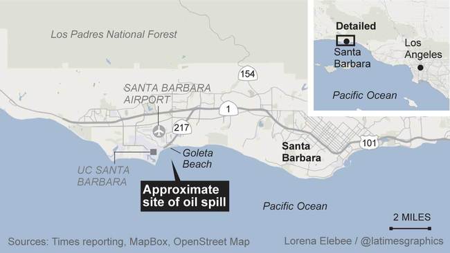
Goleta Beach oil spill“I just hoped it wasn’t another oil spill,” said Janine Dorn, a substitute teacher who brought her black poodle, Jack, to survey Goleta Beach before sunset. The oil spill in May had her fuming, she said. “Then I see this and it’s incredible. This can’t be happening again.”

Shortly before 11 a.m., the kayakers reported seeing the sheen about 1,000 feet off Goleta Beach, according to the county fire department. A black and brown gooey substance had coated the kayaks and the kayakers’ legs, according to photos from the fire department.

Initially described as measuring 60 feet wide, the sheen by Wednesday evening had stretched 3.5 miles long and half a mile wide, U.S. Coast Guard Lt. Ryan Schmid said. As tides moved, the oil split into sections and covered only about one-third of the total area, he said.

The patch was seen floating near an oil platform owned by Venoco Inc., but the company denied that its platform was involved. That platform, known as Holly, was shut down in May, a company official said. Its pipeline was flushed of any oil and refilled with seawater.

The Coast Guard, meanwhile, said the sheen could have been an ordinary, natural seepage. At Coal Oil Point, a seep field in the Santa Barbara Channel, thousands of gallons of oil flow into the ocean each day, something residents have grown accustomed to.

“The earth burps all the time,” said Robert Hernandez, an electrician who fishes nearly every day off the Goleta pier. “You smell it, you get a little on you. No big deal.”

Hernandez, 60, said he has been fishing along the Central Coast since he was 15. Sheens such as those spotted Wednesday are part of life in a region where the petroleum-rich sea bed regularly emits oil and natural gas, he said, which made him question why it was newsworthy. “It cracks me up,” he said. “At first I thought there was a shark attack or something.”

Yet environmental activist Rebecca Claassen, an organizer with Food and Water Watch, said it’s too early to minimize the sheen as a natural occurrence, saying the oil platforms that dot the county’s coastline pose a daily risk. “We can see a spill any day as long as there is drilling off shore,” she said.

Federal officials said Wednesday’s sheen also could be a remnant of this spring’s spill, when the corroded pipe operated by Plains All American Pipeline leaked an estimated 101,000 gallons of crude along the Gaviota coast and forced a weeks-long closure of Refugio State Beach.

The director of the state’s Department of Fish and Wildlife, Charlton Bonham, said Wednesday that the cleanup of the Refugio spill is ongoing, with about 14,000 gallons of oily water removed from the ocean.

Cleanup crews have responded to reports of tar balls as far away as Orange County, and one tar ball recovered in Manhattan Beach had the same oil “DNA” as the oil spilled at Refugio, he said.

Appearing in Sacramento before the state Ocean Protection Council, Bonham said the natural seepage in the area is challenging how his agency assesses the effectiveness of recovery efforts. “What is clean?” he told the panel. “How clean is clean?”

As federal and state investigators await the results of laboratory tests from Wednesday’s incident, Santa Barbara County’s director of public health, Dr. Takashi Wada, said there is no immediate risk to swimmers, and the county’s beaches and fishing piers remain open.

After swimming in the water off Goleta Beach with her friend, Anya Schmitz, 16, opined that the water was crystal clear — perfect for a summer dip.

“Conditions are great,” she said. “Seems like a lot of hype to me.”

Panzar reported from Goleta; Serna and Hamilton from Los Angeles. Times staff writer Phil Willon in Sacramento contributed to this report.

CSX Provides Update on W.Va. Oil Train Derailment Cleanup

Repost from ABC News

CSX Provides Update on W.Va. Oil Train Derailment Cleanup

By JOHN RABY Associated Press, Jul 21, 2015, 7:51 PM ET

GLEN FERRIS, W.Va. – CSX is continuing to closely monitor the environmental impact of a fiery oil-train derailment in southern West Virginia, a spokeswoman said Tuesday.The company held a public informational meeting that drew a sparse turnout Tuesday evening at the Glen Ferris Inn.

On Feb. 16, 27 cars of a CSX train’s 109 cars derailed during a snowstorm in Mount Carbon. Twenty of the cars leaked oil, some of which burned or was released into the ground.

Under a March consent order with the U.S. Environmental Protection Agency, the railroad agreed to a long-term plan for cleaning up and restoring the area around the derailment.

“It’s important for the community to know that we said we would be here,” CSX spokeswoman Melanie Cost said. “This is part of that process. We want to keep the open dialogue for them.”

Donna Shabdue lives near the derailment site and was forced to evacuate her home for more than a day. She showed up to the meeting to voice her concerns about local emergency response and pleaded for quickly informing the public about future incidents.

“They need to have a plan,” she said. “We didn’t know what to do. There needs to be a siren somewhere go off to evacuate. We didn’t know what to do. I just want out of there safely.”

The train was carrying 3 million gallons of Bakken crude and headed to Yorktown, Virginia. In recent years, trains hauling crude from the Bakken region of North Dakota and Montana have been involved in fiery derailments in six states.

The Federal Railroad Administration is investigating the West Virginia accident, which shot fireballs into the sky, burned down a nearby house and caused fires on the ground that smoldered for days.

The cause of the derailment hasn’t been released. Speed had previously been ruled out as a factor. The FRA has said the train was going 33 mph at the time of the crash. The speed limit was 50 mph.

CSX said more than 181,000 gallons of crude oil was recovered after the accident. About 10,000 tons of soil has been removed and shipped for disposal. Additional soil removal is planned next to the Kanawha River and a tributary at the derailment site.

Air, water and soil sampling continues. The water monitoring is at five locations along the river, including a drinking water intake, because of the occasional presence of oil sheens. CSX said the local drinking water supply has been unaffected by the spill.

Oil-absorbing booms were attached to a metal wall more than 410 feet long in the river as an additional containment measure. The wall will eventually be taken down once the sheens are no longer detected, Cost said.

Cost declined to disclose how much the company has spent on the cleanup.