How researchers measured history of California drought
By Valerie Trouet, September 22, 2015
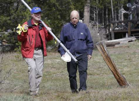
Frank Gehrke, left, chief of the California Cooperative Snow Surveys Program for the Department of Water Resources, and Gov. Jerry Brown walk across a dry meadow that is usually covered in several inches of snow as conducts the snow survey, near Echo Summit, Calif., Wednesday, April 1, 2015. Gehrke said this was the first time since he has been conducting the survey that he found no snow at this location at this time of the year. Brown took the occasion to annouced that he signed an executive order requiring the state water board to implement measures in cities and towns to cut water usage by 25 percent compared with 2013 levels. (AP Photo/Rich Pedroncelli) Photo: Rich Pedroncelli, Associated Press
In 2005, I moved to the United States from Belgium to study the influence of climate on wildfires in the Sierra Nevada over the last five centuries. As part of this work, I traveled for three months all around the mountain range to collect samples of trees and tree stumps. I stayed in remote service barracks and spent my days tromping through meadows and hiking up steep creeks to find trees that were scorched by past fires.
Thanks to the ample snows that usually fall, the Sierra has been California’s most efficient water storage system. In normal years, the mountain range’s snowpack provides 30 percent of the state’s water. It is the primary source for reservoirs that supply drinking water, agriculture and hydroelectric power. But this year, the snowpack was at just 5 percent of its 50-year average.
When California Gov. Jerry Brown declared the first-ever mandatory statewide water restriction, he chose a Sierra Nevada snow-measurement station as his backdrop. For the first time in 75 years, that station was surrounded only by dirt.
For me, Brown’s announcement worked as a call for action. After my time in the Sierra, I had realized that my main research interest — the interaction between climate and forest ecosystems — could best be pursued amid the majestic landscapes of the American West. So in 2011, I became a professor at the University of Arizona in Tucson, where I now lead a team that uncovers the past climate of California by studying its trees. I knew my research could put this year’s 2015 snow drought in a much longer context.
While there are no written documents about the climate in California from centuries ago that anyone knows of, nature itself has been writing the story of its past in many places — caves, shells, lakes and, of course, trees. My job as a paleoclimatologist is to decipher this story. Trees are remarkable creatures: In California’s Mediterranean climate, they form a growth ring every year, and the width of that ring depends, to a large extent, on that year’s climate. After a wet winter, the ring that forms is relatively wide; after a dry winter, the ring is narrow. By measuring the widths of these rings in trees that have lived for centuries, my team can “read” what the climate was like in each year over that time span. And we can extend this outlook even further by collecting older dead wood.
The amount of snow on the ground at the end of the snowy season in the Sierra is largely determined by two climate components: how much precipitation fell during winter, and how warm or cold the winter was. Temperature determines how much of the precipitation that fell was rain versus snow, and affects the speed of snowmelt. We put two tree-ring data sets together to represent precipitation and temperature over the last 500 years.
By measuring the width of the rings of more than 1,500 blue oak trees in central California, some of the most climate-sensitive trees on the planet, we were able to reliably trace Pacific Ocean storms that have traveled east over central California and brought precipitation to the Sierra Nevada. We complemented this data with a 500-year-long winter temperature record derived from tree-ring data from a variety of trees throughout the American West, which was provided by the National Oceanic and Atmospheric Administration.
By comparing these two data sets with Sierra Nevada snowpack records dating to the 1930s, we were able to reconstruct the history of snowpack in the region all the way back to the year 1500. The results, which we published last week, made national headlines: The mountain range’s 2015 snowpack level is the lowest it has been in 500 years.
To put that in perspective, this means this winter has been the worst since the first European explorer, Juan Rodriguez Cabrillo, explored California in the 1540s —about 150 years before the first mission was established. When my team started our work, we thought this year’s snow drought would be extreme, but we did not expect it to be the absolute lowest.
Sadly, while this research sheds light on the past, it’s actually not a very good barometer for the future. It very likely will not take another 500 years to reach the next record snowpack low. California temperatures are only projected to rise over the coming century. Even if the projected strong El Niño in the Pacific dumps loads of rain on Southern California this year, chances are that the Sierra Nevada snowpack will be a less reliable water source for the state going forward. This means fish and wildlife will suffer and, of course, California’s growing population of farmers, gardeners, skiers and residents are only going to keep wanting more, much more.
As I write this, the summer monsoon is rolling in over Tucson, and I am reminded that it brings a chance of redemption after a dry winter in Arizona. But California doesn’t have monsoons. Instead, in the last few days, my Twitter feed has been filled with pictures and stories of the Butte and Rough fires that are raging through the region. To me, they demonstrate the well-studied link between low snowpack, earlier spring snowmelt, and the increased risk of wildfire.
Now the ancient giant sequoia trees that left me in awe when I first saw them are at risk of being felled by drought, and even under the immediate threat of the Rough fire. To a tree-ring scientist, these 3,000-year-old trees are the enigmatic face of the power and resilience of nature. They have doubtless survived many threats and disturbances that we are not even aware of. To walk among these giants for the first time was a dream come true. Little did I realize then that I’d be keeping my fingers crossed for their survival less than a decade later.
Valerie Trouet is an associate professor in the Laboratory of Tree-Ring Research at the University of Arizona. She wrote this for Zocalo Public Square.
Federal scientists say 2015 on pace to be globe’s warmest
By Kurtis Alexander, June 18, 2015 4:23 pm
Global temperatures in May hit a record high, helping put 2015 on pace to be the hottest in history. Photo: National Oceanic And Atmospheric Administration
This year is on track to be the world’s hottest on record, federal scientists said Thursday, continuing a warming trend that even Pope Francis called worrisome in a remarkable 184-page papal letter.
Three of the world’s foremost weather agencies have reported the warmest start to any year since they began keeping records, and this week’s climate report by the National Oceanic and Atmospheric Administration found yet another chart-topping month for the globe.
May was a whopping 1.6 degrees above the 20th century average, the agency reported. California experienced average temperatures in May, but other places in the U.S., including Alaska and parts of the Northeast, made history for heat.
Still, California headed into June with a record temperature for the first five months of the year, 5.1 degrees above the 20th century average and 0.1 degrees warmer than the previous high, last year.
“We don’t do predictions here, but I would not be surprised if 2015 ends up the hottest year on record,” said Deke Arndt, a climate monitoring branch chief at the NOAA. “We’re almost halfway through the year and have a sizable lead on the pack.”
Last year currently stands as the planet’s warmest.
Climate scientists attribute the long-term trend of rising temperatures largely to human-caused bumps in greenhouse gases. The El Niño pattern that emerged earlier this year, though, is helping push the mercury to the extreme, they said. El Niños typically move heat from the ocean surface of the tropical Pacific into the atmosphere.
The upside of the El Niño is that it could bring rain to the West Coast, at least if it’s a strong system. Federal scientists are not only giving the El Niño a more than 80 percent chance of hanging on through winter — the rainy season in California — but saying that the event may be moderate or strong.
“This is starting to look like a typical El Niño footprint, something we didn’t see last year at this time,” said Steve Baxter, a forecaster for the NOAA’s Climate Prediction Center.
The past four years in California have seen below-average precipitation, and rain is desperately needed. The warm temperatures that have come with 2015, however, could mean less snow, which is critical in filling reservoirs.
Pope Francis, in an unorthodox move for the Catholic Church, weighed in on global warming this week. He tied fossil fuels to the problem and prompted a cool response from many Republican presidential candidates.
By Tom Hayden, April 24, 2015 4:32pm
LOST HILLS, CA – MARCH 24: The sun rises over an oil field over the Monterey Shale formation where gas and oil extraction using hydraulic fracturing, or fracking, is on the verge of a boom on March 24, 2014 near Lost Hills, California. Critics of fracking in California cite concerns over water usage and possible chemical pollution of ground water sources as California farmers are forced to leave unprecedented expanses of fields fallow in one of the worst droughts in California history. Concerns also include the possibility of earthquakes triggered by the fracking process which injects water, sand and various chemicals under high pressure into the ground to break the rock to release oil and gas for extraction though a well. The 800-mile-long San Andreas Fault runs north and south on the western side of the Monterey Formation in the Central Valley and is thought to be the most dangerous fault in the nation. Proponents of the fracking boom saying that the expansion of petroleum extraction is good for the economy and security by developing more domestic energy sources and increasing gas and oil exports. (Photo by David McNew/Getty Images)
Jerry Brown perhaps should put his DOGGR to sleep. Not his family dog, Sutter, but DOGGR — the Division of Oil, Gas and Geothermal Resources — the 100-year-old agency that’s been handing out permits for drilling in the Central Valley without records, oversight or enforcement of 21st century environmental laws.
The agency was created prior to Upton Sinclair’s 1927 novel, “Oil!,” on which Daniel Day-Lewis’ 2007 film, “There Will Be Blood,” was based. Oil was to California what cotton was to Mississippi, a booming industry based on subsistence labor, migration, racism, vigilantism, and government officials looking the other way.
Oil wells in the Midway-Sunset oil field in Fellows (Kern County). Monterey Shale, largely untouched territory near Midway-Sunset, could represent the future of California’s oil industry and a potential arena for conflict between drillers and the state’s powerful environmental interests. Photo: Jim Wilson, New York Times
Times change but slowly. Current Kern County Sheriff Donny Youngblood, who says Kern ought to be a county in Arizona, opposes President Obama’s immigrant-rights policy. There are an estimated 66,000 undocumented immigrants in Kern County, whose population is majority Latino. More than 22 percent of its people live below the poverty line, 69 percent of them within one mile of an oil well.
The barren place is a bit like Mississippi in the ’60s, powerful enough to defy progressive norms or laws on the national level. The federal government in 1982 transferred its power to California to monitor and regulate the 42,000 injection wells that dump toxic waste fluids into groundwater. That monitoring didn’t happen, a lapse that the feds say is shocking. The human carcinogen benzene has been detected in fracking wastewater at levels 700 times over federal safety standards. Health impact studies are inadequate, but Kern community hospital managers say the county has one of the highest cancer rates in the country, which is expected to double in 10 years.
How did it happen that the Obama Environmental Protection Agency is pushing the Jerry Brown EPA to comply with modern environmental law? The same Gov. Jerry Brown signed that 1982 agreement, giving Big Oil an opportunity to oversee itself. Those were the days when President Ronald Reagan’s Anne Gorsuch ran the federal EPA, perhaps convincing California that it could do a better job.
As a result of the 1982 transfer, the feds say California has failed at oversight and record-keeping. With the feds watching, the state has two years to implement a meaningful monitoring plan.
Brown has tried to fix the problem, which undercuts his claim that drilling and controversial fracking can be addressed by beefed up regulations instead of a moratorium on fracking that most environmentalists want. He has added more professional staff to DOGGR and installed a new director, Steve Bohlen, who promises to clean up the place. Since last summer, the agency has shut down 23 injection wells out of 2,500.
The preference of one experienced state official is to peel back DOGGR, move it to Cal EPA and turning it into a real regulatory agency instead of a lapdog for the oil industry. But Brown officials prefer the uphill task of reforming DOGGR from within, and have signaled they will veto any bill that brings the agency under state EPA jurisdiction. The Legislature is going along with his incremental approach, so far.
The task will be daunting. The DOGGR mandate has been to drill, baby, drill, says state Sen. Hannah-Beth Jackson, D-Santa Barbara. DOGGR’s legal mandate calls for “increasing the ultimate recovery of underground hydrocarbons,” not determining whether drilling or fracking are sustainable and safe for aquifers or human health. Her SB545 is still a work in progress, however. It stops the archaic custom of drilling permits being obtained and accepted without any written approvals or findings, which upsets the feds and shuts out the public. Until recently, an oil company simply gave notice of its intent to drill and was entitled to proceed unless the agency said no in writing within 10 days. Under Jackson’s bill, an application to drill will require written approval, and the paperwork will be posted on the DOGGR website. In addition, the bill will limit the Kern custom of keeping records about chemicals and water impacts confidential, even when a well has gone into production.
However, the bill’s language makes oversight optional by saying that DOGGR “may” require an operator to implement a monitoring plan. Decision-making power is devolved to the division district deputy in Kern, which is like expecting a Mississippi sheriff to carry out federal law in 1964 — or the present Kern sheriff to enforce immigration law today. Nor does the bill give the state EPA or health experts any shared authority in the permitting process.
Well derricks crowd the Kern River oil field in Bakersfield in 1912. Photo: Chevron, SFC
At the heart of the scandal is the historic power of Big Oil against the emergence of California’s clean-energy economy with its priorities of renewable resources and efficiency. The Democratic majority in Sacramento is hobbled by a pro-drilling contingent, led by Republicans with a number of Central Valley Democrats. The oil lobby spent $9 million in 2014 in a failed attempt to exempt themselves from the state’s cap-and-trade law. The effort was led by Assemblyman Henry Perea, D-Fresno, along with 16 Democratic legislators. In a more striking example, state Sen. Michael Rubio, D-Bakersfield, left his seat in 2013 to begin lobbying for Chevron, one of the major firms along with Occidental Petroleum operating in Kern’s oil fields. The oil lobby is spending large sums to cultivate friendly Democratic candidates and underwrite advertising campaigns warning of a “hidden gas tax” if their privileges are threatened.
Many Sacramento insiders believe that Brown has made concessions to Big Oil in order to protect his considerable progress toward clean-energy goals while not confronting the industry the way he took on the nuclear lobby in the ’70s. That’s understandable, if it works. Now, however, his regulatory reputation needs rebuilding. What if his DOGGR won’t hunt? What if it’s beyond reform? What will the governor and Legislature do if facing open defiance from the powers that be in Kern on a range of issues from clean air and water to the protection of children’s health to environmental justice? With the drought on everyone’s mind, can he allow the state’s aquifers to be threatened by the carcinogenic wastewater of oil production?
The DOGGR scandal drills deeply into the foundations on which state politics are built.
Tom Hayden writes, speaks and consults on climate politics and serves on the editorial board of the Nation. His latest book is “Listen Yankee!: Why Cuba Matters.” (Seven Stories Press, 2015).
In California, Farmers Rely on Oil Wastewater to Weather Drought
By Zoë Schlanger / April 6, 2015 6:54 AM EDT
Overlooking Chevron’s Kern River oil field with the Sierra Nevada in the background, March 30, 2015. Percy Feinstein/Corbis
The wet, white noise of gushing water rises above a background track of twangy guitar. Water is tumbling out of a pipe into a holding pond that looks as though it has sat nearly empty for ages, its sandy sides the color of parched desert. It looks like the California of recent headlines: drought so bad the ground is blowing away. Except now, here, in this promotional video for Chevron, there is water. Lots of it.
“The sound of that water is music to my ears,” David Ansolabehere, the general manager of the Cawelo Water District in Kern County, says in the video, gazing out over the rapidly filling pond. “Chevron is being environmentally conscious, and this is a very beneficial program, and it’s helped a lot of our farmers, helped our district, tremendously.”
The oil fields of Kern County, where Chevron is the largest producer, pump out more oil than those of any other county in the United States. It also happens to be one of the country’s most prolific agricultural counties, producing over $6 billion in crop value every year. But after three years of strangling drought, all that agriculture is on life support.
That’s where Chevron comes in. For every barrel of oil Chevron produces in its Kern River oil field, another 10 barrels of salty wastewater come up with it. So Chevron is selling about 500,000 barrels of water per day, or 21 million gallons, back to the Cawelo Water District—the local water district that delivers water to farmers within a seven-mile slice of Kern County—at an undisclosed amount, but “essentially ‘at cost,’” according to Chevron spokesman Cameron Van Ast. In a time when freshwater in the Central Valley is selling at up to 10 times the typical cost, it’s a good deal for farmers.
The wastewater Chevron is selling flows, without municipal treatment (though the oil products are removed), to 90 local farmers who spread it on their citrus, nut and grape crops. The Cawelo Water District might first mix the wastewater with freshwater, or it might not, depending on what crop the wastewater will be used on—and on how much freshwater is available at the time. In the midst of a drought, there is less freshwater, so the water the farmers get is saltier than in a wet year. But the farmers understand that using the salty wastewater on their crops is an emergency measure. If all goes as planned, when the rains come back the excess salt will be flushed through the soil.
But it’s a risky dance; over time, high sodium can change the properties of the soil, making it impermeable, unable to take in any more water. Trees would start to get “salt burn.” Their leaves would turn yellow, and yields would decline. Eventually, the soil becomes barren.
Ansolabehere says the wastewater mixture sent to farmers is rigorously monitored to keep from salting the soil to that degree. It is tested quarterly for salts and boron, he says. “The only reason this program works is because [Chevron’s] production water is of very good quality,” he says. “So maybe we’ll have a little salt buildup. But the next rain will flush it out.”
But the National Weather Service doesn’t foresee much rain in the immediate future. In fact, drought conditions may “intensify.”
For local farmers, dwindling water is a noose slowly tightening. Most take relief wherever they can get it, but not Tom Frantz. “I would rather let my trees die” than use the Chevron water, he says. Frantz is a small-time almond farmer who lives about six miles from the oilfields where the wastewater is pumped into mixing basins. His 36 acres are a speck in the shadow of much larger operations; vast orange groves, pistachio trees, rows and rows of almond trees. But Frantz knows farming. He’s been in Kern County, just west of the town Shafter, for all of his 65 years. His grandparents were farmers a few miles away. His parents farmed, too. There’s a generation below him, he says, who look as if they’ll take it up soon.
In normal years, Frantz depends on groundwater pumped from wells, as well as “surface water,” the water held in municipal reservoirs that flows in frigid streams from the melting snowpack in the Sierra Nevada mountains. But with the Sierra snowpack this winter at a paltry 6 percent of its typical heft, there won’t be much to melt. Chevron’s wastewater is an option, but Frantz knows what all farmers know: You can’t grow food with salty water for very long.
Irrigation water runs along the dried-up ditch between the rice farms to provide water for the rice fields in Richvale, California, May 1, 2014. Jae C. Hong/AP
“It’s just not sustainable at all to use salty water, no matter how much you dilute it…. We can farm here a long time, if we’re careful about the salts that we apply,” he says. “I’ve seen the farms that have saltier groundwater, and they have severe difficulties after 50 years. That’s very low levels of salts that’ll do that.”
Frantz has little confidence in how oil industry wastewater is regulated in his area, and he is concerned by what still isn’t known about the contents of the wastewater. Recently, there was a scandal over news that state oil and gas officials for years let oil companies inject drilling and fracking wastewater into hundreds of wells in protected aquifers. The water was laden with the benzene, a carcinogen, according to a Los Angeles Times investigation. “What it shows me is that we have to look out for ourselves,” Frantz says.
California doesn’t have statewide regulations for recycling wastewater for agriculture. Instead, nine regional water boards issue permits to local water districts. Once a year, the Cawelo Water District is required to send data about the salt and boron content to the Central Valley Water Board, according to Clay Rodgers, the board’s assistant executive officer. But the district isn’t obligated to test for other components, like heavy metals, arsenic, radioactive materials and chemicals that might be used in the drilling process. Ansolabehere says Cawelo has tested for radioactive elements “a couple of times” over the past 20 years, since “it’s very expensive” to test for, and it isn’t required by the board. Those tests have not turned up any positive results.
Chevron, for its part, says testing last month showed no heavy metals or chemical toxins were present in the water above maximum allowable levels. The arsenic levels were high, however, but “issues related to the arsenic concentrations in the water were fully addressed in the process of obtaining the permit from the Central Valley Regional Water Quality Control Board,” Chevron said in a statement. “Protection of people and the environment is a core value for Chevron, and we take all necessary steps to ensure the protection of our water resources.”
The Central Valley Regional Water Quality Control Board came to the conclusion that the high arsenic in the waste water was acceptable because most of the arsenic appeared in models to get “tied up” in the soil as it made its way down to the water table, says Rodgers. In other words, the Board sees no threat of tainting the groundwater with arsenic, because it largely stays in the soil. But no monitoring is in place to see if that arsenic is building up to unsafe levels in the agricultural soils themselves.
Little to no independent scientific research has been done on this type of water and how it interacts with crops, soil and surrounding bodies of water. Some scientists say there are too many unknowns associated with the wastewater from oilfields. If it is being used on food, and to irrigate land that lies above drinking water aquifers, we need to know more about it, they say—especially in light of the fact that, as Rodgers notes, the Central Valley hopes to expand its use for farm irrigation during the drought.
“There might not be a single risk out there with this practice. But the biggest risk that we have right now is that we just don’t know,” says Seth Shonkoff, an environmental public health scientist and a visiting scholar at the University of California, Berkeley. “So until we know, we definitely have reason for concern. We know that there are compounds being put down oil and gas wells that you would not want in your food.”
To Shonkoff’s knowledge, no scientist has ever published a study on what compounds from the oil development process—examples he gives are methanol, biocides and surfactants—might be in oilfield wastewater used on crops. Chevron says these constituents are kept separate from the water delivered to farmers.
Avner Vengosh, a Duke University geochemist, is serving on an expert panel for the U.S. Geological Survey while it begins to look into the quality of produced oil-field water from Kern County. His data are “only preliminary,” but he has found “high levels of vanadium, chromium and selenium” in the samples of wastewater he has tested (although he was unable to say if the water was produced from Chevron’s operations or another of the many operators in the area). Those levels are consistent with data from oil- and gas-produced water from other basins in the U.S., according to Vengosh.
Vanadium, a metal, is classified as “possibly carcinogenic” by the International Agency for Research on Cancer. Certain forms of chromium and selenium, both heavy metals, are associated with myriad health problems, including cancer, from chronic high exposure. Ansolabehere says the Cawelo Water District tested for chromium and selenium once, last year, and found none. It has never tested for vanadium. None of these metals are required to be tested for by the Central Valley Water Board.
Could the crops be absorbing these metals? The California Department of Food and Agriculture says it doesn’t have the jurisdiction to look. The Central Valley Water Board doesn’t sample crop residues where the water is used, either.
For Vengosh, what is most worrisome is the possibility that the water is seeping through the farmland into the water table. “It would end up in underlying groundwater. If the groundwater is moving to a drinking water source, you would end up with that in the drinking water eventually,” he says.
No matter how tough the drought gets, Frantz says, he won’t be taking the Chevron water. “It just doesn’t make sense to ruin something,” he says. “To get through years like this, we have to take some land out of production.”
But for Roy Pierucci, a farmer who manages a 160-acre pistachio farm that falls within the Cawelo Water District, the unknowns about the Chevron water won’t deter him from using it. If the water contains some as of yet unknown elements, “it would be a risk we’d be willing to take,” he says, without hesitation. He’s been using the Chevron water for 10 years and has never seen a problem with his crops. (Pierucci was featured in the Chevron promotional video, though he wasn’t paid for the appearance—he says he participated because he values what the company does for the water district.)
“I’ve really never asked what the analysis of the water is. I just know it’s available. There hasn’t been any complaints about it. I don’t think they recommend drinking it,” Pierucci says. “If [the drought] keeps up year after year, I think it would be a concern. I think the salt levels would be higher. They blend it for a reason.”
The Chevron water is vital to Pierucci’s operation, but it isn’t a game changer. “It’s not going to save us,” he says. Three years of brutal drought have left his pistachio trees teetering on the edge of survival. If the drought persists another two or three years, he says, he’ll have to start ripping out his trees and reducing the number of acres he irrigates. On another property he manages, where there is no pumping well on-site, he imagines he’ll be pulling out trees within a year. “You can’t chase water forever. Sooner or later you’re going to lose.”
This article has been updated to include a statement from Chevron regarding their internal water testing processes and results, as well as information about arsenic monitoring from the Central Valley Regional Water Quality Control Board.